ui-material-components
Monorepo that contains all of the NativeScript Material Design plugins.
- 234
- TypeScript
- Apache-2.0
- 6 wk ago
Interactive, thoroughly customizable maps powered by vector tiles and OpenGL.
Repo nativescript-community/ui-mapbox, read from GitHub 1 min ago. nativescript-community has not joined Take My Repo.
nativescript-community/ui-mapbox is a public repo on GitHub by nativescript-community. Interactive, thoroughly customizable maps powered by vector tiles and OpenGL. It declares no license on GitHub. Public does not mean open source: without a license, nobody is granted the right to reuse it. It is written mainly in TypeScript, has 37 stars and last changed on 2026-09-16. Nobody has reviewed it on Take My Repo yet, which says nothing about its quality. Read from GitHub on 2026-11-21.
Interactive, thoroughly customizable maps powered by vector tiles and OpenGL.
You either need your own tile server such as the one provided by openmaptiles.org or a Mapbox API access token (they have a 🆓 Starter plan!), so sign up with Mapbox. Once you've registered go to your Account > Apps > New token. The 'Default Secret Token' is what you'll need.
Mapbox now requires an api key to download the sdk on Android. You can pass it through gradle properties or env variable under the name MAPBOX_DOWNLOADS_TOKEN
Run the following command from the root of your project:
ns plugin add @nativescript-community/ui-mapbox
Add any other additional configuration instructions here.
If you get an error during iOS build related to Podspec versions, probably the easiest fix is:
ns platform remove ios and ns platform add ios.
On Android the plugin adds this to the <application> node of app/App_Resources/Android/AndroidManifest.xml (the plugin already attempts to do so):
<service android:name="com.mapbox.services.android.telemetry.service.TelemetryService" />
If you get an error related to TelemetryService then please check it's there.
You can instantiate a map from JS or TS. As the map is yet another view component it will play nice with any NativeScript layout you throw it in. You can also easily add multiple maps to the same page or to different pages in any layout you like.
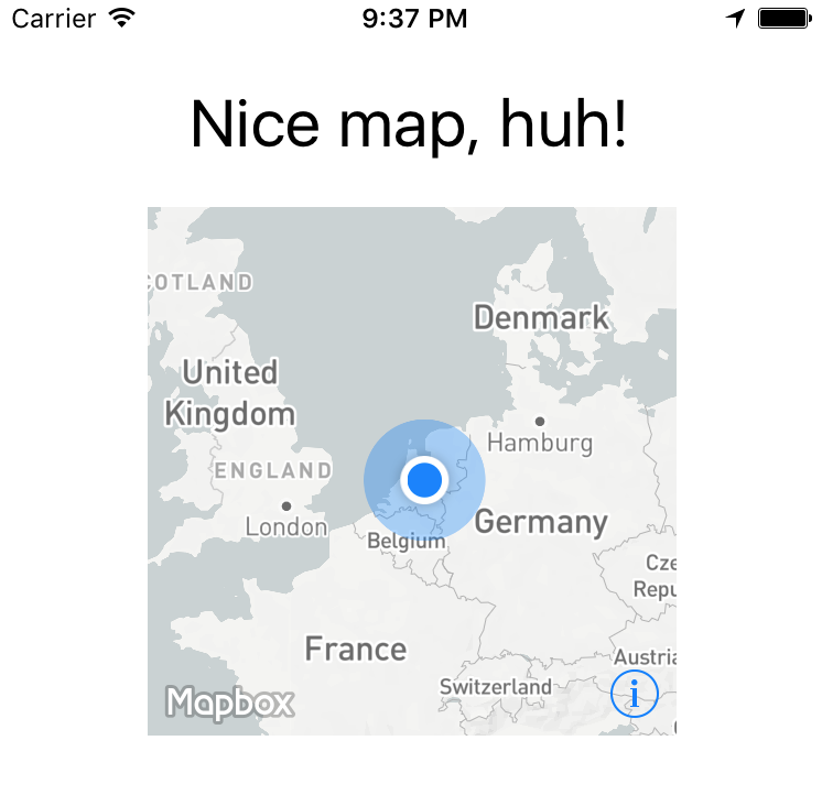
A simple layout could look like this:
Could be rendered by a definition like this:
<Page xmlns="http://schemas.nativescript.org/tns.xsd" xmlns:map="@nativescript-community/ui-mapbox" navigatingTo="navigatingTo">
  <StackLayout>
    <Label text="Nice map, huh!" class="title"/>
    <ContentView height="240" width="240">
      <map:MapboxView
          accessToken="your_token"
          mapStyle="traffic_night"
          latitude="52.3702160"
          longitude="4.8951680"
          zoomLevel="3"
          showUserLocation="true"
          mapReady="onMapReady">
      </map:MapboxView>
    </ContentView>
  </StackLayout>
</Page>
Component:
import { registerElement } from '@nativescript/angular';
registerElement("Mapbox", () => require("@nativescript-community/ui-mapbox").MapboxView);
View:
  <ContentView height="100%" width="100%">
    <Mapbox
        accessToken="your_token"
        mapStyle="traffic_day"
        latitude="50.467735"
        longitude="13.427718"
        hideCompass="true"
        zoomLevel="18"
        showUserLocation="false"
        disableZoom="false"
        disableRotation="false"
        disableScroll="false"
        disableTilt="false"
        (mapReady)="onMapReady($event)">
    </Mapbox>
  </ContentView>
All currently supported options for your XML based map are (don't use other properties - if you need styling wrap the map in a ContentView and apply things like width to that container!):
| option | default | description |
|---|---|---|
accesstoken |
- | see 'Prerequisites' above |
delay |
0 | A delay in milliseconds - you can set this to have better control over when Mapbox is invoked so it won't clash with other computations your app may need to perform. |
mapStyle |
streets | streets, light, dark, satellite_streets, satellite, traffic_day, traffic_night, an URL starting with mapbox:// or pointing to a custom JSON definition (http://, https://, or local relative to nativescript app path ~/) |
latitude |
- | Set the center of the map by passing this in |
longitude |
- | .. and this as well |
zoomLevel |
0 | 0-20 |
showUserLocation |
false | Requires location permissions on Android which you can remove from AndroidManifest.xml if you don't need them |
hideCompass |
false | Don't show the compass in the top right corner during rotation of the map |
hideLogo |
false | Mapbox requires false if you're on a free plan |
hideAttribution |
true | Mapbox requires false if you're on a free plan |
disableZoom |
false | Don't allow the user to zoom in or out (pinch and double-tap) |
disableRotation |
false | Don't allow the user to rotate the map (two finger gesture) |
disableScroll |
false | Don't allow the user to move the center of the map (one finger drag) |
disableTilt |
false | Don't allow the user to tilt the map (two finger drag up or down) |
mapReady |
- | The name of a callback function you can declare to interact with the map after it has been drawn |
moveBeginEvent |
- | The name of a function to be called when the map has begun to move. |
moveEndEvent |
- | The name of a function to be called when the map has completed moving. |
locationPermissionGranted |
- | The name of a callback function you can declare to get notified when the user granted location permissions |
locationPermissionDenied |
- | The name of a callback function you can declare to get notified when the user denied location permissions (will never fire on iOS because there's nothing to deny) |
This is where that last option in the table above comes in - mapReady.
It allows you to interact with the map after it has been drawn to the page.
Open main-page.[js|ts] and add this (see addMarkers further below for the full marker API):
var mapbox = require("@nativescript-community/ui-mapbox");

function onMapReady(args) {
  // you can tap into the native MapView objects (MGLMapView for iOS and com.mapbox.mapboxsdk.maps.MapView for Android)
  var nativeMapView = args.ios ? args.ios : args.android;
  console.log("Mapbox onMapReady for " + (args.ios ? "iOS" : "Android") + ", native object received: " + nativeMapView);

  // .. or use the convenience methods exposed on args.map, for instance:
  args.map.addMarkers([
    {
      lat: 52.3602160,
      lng: 4.8891680,
      title: 'One-line title here',
      subtitle: 'Really really nice location',
      selected: true, // makes the callout show immediately when the marker is added (note: only 1 marker can be selected at a time)
      onCalloutTap: function(){console.log("'Nice location' marker callout tapped");}
    }]
  );
}

exports.onMapReady = onMapReady;
var mapbox = require("@nativescript-community/ui-mapbox");

function onMapReady(args) {
  args.map.setViewport(
      {
        bounds: {
          north: 52.4820,
          east: 5.1087,
          south: 52.2581,
          west: 4.6816
        },
        animated: true
      }
  );
}

exports.onMapReady = onMapReady;
The methods you can invoke like this from an XML-declared map are:
addMarkers, setViewport, removeMarkers, getCenter, setCenter, getZoomLevel, setZoomLevel, getViewport, getTilt, setTilt, setMapStyle, animateCamera, addPolygon, removePolygons, addPolyline, removePolylines, getUserLocation, trackUser, setOnMapClickListener, setOnMapLongClickListener and destroy.
Check out the usage details on the functions below.
Add a container to your view XML where you want to programmatically add the map. Give it an id.
<ContentView id="mapContainer" />
    const contentView : ContentView = <ContentView>page.getViewById( 'mapContainer' );

    const settings = {

      // NOTE: passing in the container here.

      container: contentView,
      accessToken: ACCESS_TOKEN,
      style: MapStyle.LIGHT,
      margins: {
        left: 18,
        right: 18,
        top: isIOS ? 390 : 454,
        bottom: isIOS ? 50 : 8
      },
      center: {
        lat: 52.3702160,
        lng: 4.8951680
      },
      zoomLevel: 9, // 0 (most of the world) to 20, default 0
      showUserLocation: true, // default false
      hideAttribution: true, // default false
      hideLogo: true, // default false
      hideCompass: false, // default false
      disableRotation: false, // default false
      disableScroll: false, // default false
      disableZoom: false, // default false
      disableTilt: false, // default false
      markers: [
        {
          id: 1,
          lat: 52.3732160,
          lng: 4.8941680,
          title: 'Nice location',
          subtitle: 'Really really nice location',
          iconPath: 'res/markers/green_pin_marker.png',
          onTap: () => console.log("'Nice location' marker tapped"),
          onCalloutTap: () => console.log("'Nice location' marker callout tapped")
        }
      ]
    };

    console.log( "main-view-model:: doShow(): creating new MapboxView." );

    const mapView = new MapboxView();

    // Bind some event handlers onto our newly created map view.

    mapView.on( 'mapReady', ( args : any ) => {

      console.log( "main-view-model: onMapReady fired." );

      // this is an instance of class MapboxView

      this.mapboxView = args.map;

      // get a reference to the Mapbox API shim object so we can directly call its methods.

      this.mapbox = this.mapboxView.getMapboxApi();

      this.mapbox.setOnMapClickListener( point => {
        console.log(`>> Map clicked: ${JSON.stringify(point)}`);
        return true;
      });

      this.mapbox.setOnMapLongClickListener( point => {
        console.log(`>> Map longpressed: ${JSON.stringify(point)}`);
        return true;
      });

      this.mapbox.setOnScrollListener((point: LatLng) => {
        // console.log(`>> Map scrolled`);
      });

      this.mapbox.setOnFlingListener(() => {
        console.log(`>> Map flinged"`);
      }).catch( err => console.log(err) );

    });

    mapView.setConfig( settings );
    contentView.content = mapView;
All further examples assume mapbox has been required.
Also, all functions support promises, but we're leaving out the .then() stuff for brevity where it doesn't add value.
mapbox.hide();
If you previously called hide() you can quickly unhide the map,
instead of redrawing it (which is a lot slower and you loose the viewport position, etc).
mapbox.unhide();
To clean up the map entirely you can destroy instead of hide it:
mapbox.destroy();
You can update the map style after you've loaded it.
With Mapbox Android SDK 6.1.x (used in plugin version 4.1.0) I've seen Android crash a few seconds after this has been used, so test this well and perhaps don't use it when in doubt.
mapbox.setMapStyle(mapbox.MapStyle.DARK);
  import { MapboxMarker } from "@nativescript-community/ui-mapbox";

  const firstMarker = <MapboxMarker>{ //cast as a MapboxMarker to pick up helper functions such as update()
    id: 2, // can be user in 'removeMarkers()'
    lat: 52.3602160, // mandatory
    lng: 4.8891680, // mandatory
    title: 'One-line title here', // no popup unless set
    subtitle: 'Infamous subtitle!',
    // icon: 'res://cool_marker', // preferred way, otherwise use:
    icon: 'http(s)://website/coolimage.png', // from the internet (see the note at the bottom of this readme), or:
    iconPath: '~/assets/markers/home_marker.png',
    selected: true, // makes the callout show immediately when the marker is added (note: only 1 marker can be selected at a time)
    onTap: marker => console.log("Marker tapped with title: '" + marker.title + "'"),
    onCalloutTap: marker => alert("Marker callout tapped with title: '" + marker.title + "'")
  };

  mapbox.addMarkers([
    firstMarker,
    {
      // more markers..
    }
  ])
Plugin version 4.2.0 added the option to update makers. Just call update on the MapboxMarker reference you created above.
You can update the following properties (all but the icon really):
  firstMarker.update({
    lat: 52.3622160,
    lng: 4.8911680,
    title: 'One-line title here (UPDATE)',
    subtitle: 'Updated subtitle',
    selected: true, // this will trigger the callout upon update
    onTap: (marker: MapboxMarker) => console.log(`UPDATED Marker tapped with title: ${marker.title}`),
    onCalloutTap: (marker: MapboxMarker) => alert(`UPDATED Marker callout tapped with title: ${marker.title}`)
  })
You can either remove all markers by not passing in an argument, or remove specific marker id's (which you specified previously).
  // remove all markers
  mapbox.removeMarkers();

  // remove specific markers by id
  mapbox.removeMarkers([1, 2]);
If you want to for instance make the viewport contain all markers you can set the bounds to the lat/lng of the outermost markers using this function.
  mapbox.setViewport(
      {
        bounds: {
          north: 52.4820,
          east: 5.1087,
          south: 52.2581,
          west: 4.6816
        },
        animated: true // default true
      }
  )
  mapbox.getViewport().then(
      function(result) {
        console.log("Mapbox getViewport done, result: " + JSON.stringify(result));
      }
  )
  mapbox.setCenter(
      {
        lat: 52.3602160, // mandatory
        lng: 4.8891680, // mandatory
        animated: false // default true
      }
  )
Here the promise callback makes sense, so adding it to the example:
  mapbox.getCenter().then(
      function(result) {
        console.log("Mapbox getCenter done, result: " + JSON.stringify(result));
      },
      function(error) {
        console.log("mapbox getCenter error: " + error);
      }
  )
  mapbox.setZoomLevel(
      {
        level: 6.5, // mandatory, 0-20
        animated: true // default true
      }
  )
  mapbox.getZoomLevel().then(
      function(result) {
        console.log("Mapbox getZoomLevel done, result: " + JSON.stringify(result));
      },
      function(error) {
        console.log("mapbox getZoomLevel error: " + error);
      }
  )
  // this is a boring triangle drawn near Amsterdam Central Station
  mapbox.animateCamera({
    // this is where we animate to
    target: {
        lat: 52.3732160,
        lng: 4.8941680
    },
    zoomLevel: 17, // Android
    altitude: 2000, // iOS (meters from the ground)
    bearing: 270, // Where the camera is pointing, 0-360 (degrees)
    tilt: 50,
    duration: 5000 // default 10000 (milliseconds)
  })
  mapbox.setTilt(
      {
        tilt: 40, // default 30 (degrees angle)
        duration: 4000 // default 5000 (milliseconds)
      }
  )
  mapbox.getTilt().then(
      function(tilt) {
        console.log("Current map tilt: " +  tilt);
      }
  )
If the user's location is shown on the map you can get their coordinates and speed:
  mapbox.getUserLocation().then(
      function(userLocation) {
        console.log("Current user location: " +  userLocation.location.lat + ", " + userLocation.location.lng);
        console.log("Current user speed: " +  userLocation.speed);
      }
  )
In case you're showing the user's location, you can have the map track the position. The map will continuously move along with the last known location.
  mapbox.trackUser({
    mode: "FOLLOW_WITH_HEADING", // "NONE" | "FOLLOW" | "FOLLOW_WITH_HEADING" | "FOLLOW_WITH_COURSE"
    animated: true
  });
https://docs.mapbox.com/mapbox-gl-js/api/#map#addsource
Supported source types:
Adds a vector to GeoJSON source to the map.
  mapbox.addSource( id, {
    type: 'vector',
    url: 'url to source'
  } );
-or-
  mapbox.addSource( id, {
    'type': 'geojson',
    'data': {
      "type": "Feature",
        "geometry": {
        "type": "LineString",
          "coordinates": [ [ lng, lat ], [ lng, lat ], ..... ]
        }
      }
    }
  );
Remove a source by id
mapbox.removeSource( id );
https://docs.mapbox.com/mapbox-gl-js/style-spec/#layers
Supported layer types:
To add a line:
  mapbox.addLayer({
    'id': someid,
    'type': 'line',
    'source': {
      'type': 'geojson',
      'data': {
        "type": "Feature",
          "geometry": {
          "type": "LineString",
            "coordinates": [ [ lng, lat ], [ lng, lat ], ..... ]
          }
        }
      }
    },
    'layout': {
      'line-cap': 'round',
      'line-join': 'round'
    },
    'paint': {
      'line-color': '#ed6498',
      'line-width': 5,
      'line-opacity': .8,
      'line-dash-array': [ 1, 1, 1, ..]
    }
  });
To add a circle:
  mapbox.addLayer({
    "id": someid,
    "type": 'circle',
    "source": {
      "type": 'geojson',
      "data": {
        "type": "Feature",
        "geometry": {
          "type": "Point",
          "coordinates": [ lng, lat ]
        }
      }
    },
    "paint": {
      "circle-radius": {
        "stops": [
          [0, 0],
          [20, 8000 ]
        ],
        "base": 2
      },
      'circle-opacity': 0.05,
      'circle-color': '#ed6498',
      'circle-stroke-width': 2,
      'circle-stroke-color': '#ed6498'
    }
  });
Source may be a geojson or vector source description or may be the id of a source added using addSource()
Remove a layer added with addLayer() by id.
mapbox.removeLayer( id );
https://docs.mapbox.com/mapbox-gl-js/api/map/#map#queryrenderedfeatures Returns an array of GeoJSON Feature objects representing visible features that satisfy the query parameters.
mapbox
  .queryRenderedFeatures({
    point: {
      lat: 52.3701494345567,
      lng: 4.823684692382513,
  	},
    layers: ['circle-with-source-object'],
    filter: ['==', ['get', 'querySample'], '2'],
  })
  .then((result) => console.log('query rendered features', result))
https://docs.mapbox.com/mapbox-gl-js/api/map/#map#querysourcefeatures Returns an array of GeoJSON Feature objects representing features within the specified vector tile or GeoJSON source that satisfy the query parameters.
mapbox
  .querySourceFeatures('source_id', { filter: ['==', ['get', 'querySample'], '2'] })
  .then((result) => console.log('query source features', result));
Dynamically add a point to a line.
mapbox.addLinePoint( <id of line layer>, lnglat )
where lnglat is an array of two points, a longitude and a latitude.
Draw a shape. Just connect the dots like we did as a toddler.
The first person to tweet a snowman drawn with this function gets a T-shirt (from @eddyverbruggen ;-)).
  // after adding this, scroll to Amsterdam to see a semi-transparent red square
  mapbox.addPolygon(
      {
        id: 1, // optional, can be used in 'removePolygons'
        fillColor: new Color("red"),
        fillOpacity: 0.7,

        // stroke-related properties are only effective on iOS
        strokeColor: new Color("green"),
        strokeWidth: 8,
        strokeOpacity: 0.5,

        points: [
          {
            lat: 52.3923633970718,
            lng: 4.902648925781249
          },
          {
            lat: 52.35421556258807,
            lng: 4.9308013916015625
          },
          {
            lat: 52.353796172573944,
            lng: 4.8799896240234375
          },
          {
            lat: 52.3864966440161,
            lng: 4.8621368408203125
          },
          {
            lat: 52.3923633970718,
            lng: 4.902648925781249
          }
        ]
      })
      .then(result => console.log("Mapbox addPolygon done"))
      .catch((error: string) => console.log("mapbox addPolygon error: " + error));
You can either remove all polygons by not passing in an argument, or remove specific polygon id's (which you specified previously).
  // remove all polygons
  mapbox.removePolygons();

  // remove specific polygons by id
  mapbox.removePolygons([1, 2]);
Deprecated. Use addLayer() instead.
Draw a polyline. Connect the points given as parameters.
  // Draw a two segment line near Amsterdam Central Station
  mapbox.addPolyline({
      id: 1, // optional, can be used in 'removePolylines'
      color: '#336699', // Set the color of the line (default black)
      width: 7, // Set the width of the line (default 5)
      opacity: 0.6, //Transparency / alpha, ranging 0-1. Default fully opaque (1).
      points: [
          {
              'lat': 52.3833160, // mandatory
              'lng': 4.8991780 // mandatory
          },
          {
              'lat': 52.3834160,
              'lng': 4.8991880
          },
          {
              'lat': 52.3835160,
              'lng': 4.8991980
          }
      ]
  });
Deprecated. Use removeLayer() instead.
You can either remove all polylines by not passing in an argument, or remove specific polyline id's (which you specified previously).
  // remove all polylines
  mapbox.removePolylines();

  // remove specific polylines by id
  mapbox.removePolylines([1, 2]);
Add a listener to retrieve lat and lng of where the user taps the map (not a marker).
  mapbox.setOnMapClickListener((point: LatLng) => {
    console.log("Map clicked at latitude: " + point.lat + ", longitude: " + point.lng);
  });
Add a listener to retrieve lat and lng of where the user longpresses the map (not a marker).
  mapbox.setOnMapLongClickListener((point: LatLng) => {
    console.log("Map longpressed at latitude: " + point.lat + ", longitude: " + point.lng);
  });
Add a listener to retrieve lat and lng of where the user scrolls to on the map.
  mapbox.setOnScrollListener((point?: LatLng) => {
    console.log("Map scrolled to latitude: " + point.lat + ", longitude: " + point.lng);
  });
For situations where you want the user to pre-load certain regions you can use these methods to create and remove offline regions.
Important read: the offline maps documentation by Mapbox.
This example downloads the region 'Amsterdam' on zoom levels 9, 10 and 11 for map style 'outdoors'.
  mapbox.downloadOfflineRegion(
    {
      accessToken: accessToken, // required for Android in case no map has been shown yet
      name: "Amsterdam", // this name can be used to delete the region later
      style: mapbox.MapStyle.OUTDOORS,
      minZoom: 9,
      maxZoom: 11,
      bounds: {
        north: 52.4820,
        east: 5.1087,
        south: 52.2581,
        west: 4.6816
      },
      // this function is called many times during a download, so
      // use it to show an awesome progress bar!
      onProgress: function (progress) {
        console.log("Download progress: " + JSON.stringify(progress));
      }
    }
  ).then(
    function() {
      console.log("Offline region downloaded");
    },
    function(error) {
      console.log("Download error: " + error);
    }
  );
Grab the viewport with the mapbox.getViewport() function and download it at various zoom levels:
  // I spare you the error handling on this one..
  mapbox.getViewport().then(function(viewport) {
    mapbox.downloadOfflineRegion(
      {
        name: "LastViewport", // anything you like really
        style: mapbox.MapStyle.LIGHT,
        minZoom: viewport.zoomLevel,
        maxZoom: viewport.zoomLevel + 2, // higher zoom level is lower to the ground
        bounds: viewport.bounds,
        onProgress: function (progress) {
          console.log("Download %: " + progress.percentage);
        }
      }
    );
  });
To help you manage offline regions there's a listOfflineRegions function you can use. You can then fi. call deleteOfflineRegion (see below) and pass in the name to remove any cached region(s) you like.
  mapbox.listOfflineRegions({
    // required for Android in case no map has been shown yet
    accessToken: accessToken
  }).then(
    function(regions) {
      console.log(JSON.stringify(JSON.stringify(regions));
    },
    function(error) {
      console.log("Error while listing offline regions: " + error);
    }
  );
You can remove regions you've previously downloaded. Any region(s) matching the name param will be removed locally.
  mapbox.deleteOfflineRegion({
    name: "Amsterdam"
  }).then(
    function() {
      console.log("Offline region deleted");
    },
    function(error) {
      console.log("Error while deleting an offline region: " + error);
    }
  );
On Android 6 you need to request permission to be able to show the user's position on the map at runtime when targeting API level 23+.
Even if the uses-permission tag for ACCESS_FINE_LOCATION is present in AndroidManifest.xml.
You don't need to do this with plugin version 2.4.0+ as permission is request when required while rendering the map. You're welcome :)
Note that hasFineLocationPermission will return true when:
  mapbox.hasFineLocationPermission().then(
      function(granted) {
        // if this is 'false' you probably want to call 'requestFineLocationPermission' now
        console.log("Has Location Permission? " + granted);
      }
  );

  // if no permission was granted previously this will open a user consent screen
  mapbox.requestFineLocationPermission().then(
      function() {
        console.log("Location permission requested");
      }
  );
Note that the show function will also check for permission if you passed in showUserLocation : true.
If you didn't request permission before showing the map, and permission was needed, the plugin will ask the user permission while rendering the map.
If you specify icon: 'http(s)://some-remote-image', then on iOS you'll need to whitelist
the domain. Google for iOS ATS for detailed options, but for a quick test you can add this to
app/App_Resources/iOS/Info.plist:
	<key>NSAppTransportSecurity</key>
	<dict>
        <key>NSAllowsArbitraryLoads</key>
        <true/>
	</dict>
The repo uses submodules. If you did not clone with --recursive then you need to call
git submodule update --init
The package manager used to install and link dependencies must be pnpm or yarn. npm wont work.
To develop and test:
if you use yarn then run yarn
if you use pnpm then run pnpm i
Interactive Menu:
To start the interactive menu, run npm start (or yarn start or pnpm start). This will list all of the commonly used scripts.
npm run build.all
WARNING: it seems yarn build.all wont always work (not finding binaries in node_modules/.bin) which is why the doc explicitly uses npm run
npm run demo.[ng|react|svelte|vue].[ios|android]

npm run demo.svelte.ios # Example
Demo setup is a bit special in the sense that if you want to modify/add demos you dont work directly in demo-[ng|react|svelte|vue]
Instead you work in demo-snippets/[ng|react|svelte|vue]
You can start from the install.ts of each flavor to see how to register new demos
You can update the repo files quite easily
First update the submodules
npm run update
Then commit the changes Then update common files
npm run sync
Then you can run yarn|pnpm, commit changed files if any
npm run readme
npm run doc
The publishing is completely handled by lerna (you can add -- --bump major to force a major release)
Simply run
npm run publish
The repo uses https:// for submodules which means you won't be able to push directly into the submodules.
One easy solution is t modify ~/.gitconfig and add
[url "ssh://git@github.com/"]
	pushInsteadOf = https://github.com/
If you have any questions/issues/comments please feel free to create an issue or start a conversation in the NativeScript Community Discord.
The repo uses submodules. If you did not clone with --recursive then you need to call
git submodule update --init
The package manager used to install and link dependencies must be pnpm or yarn. npm wont work.
To develop and test:
if you use yarn then run yarn
if you use pnpm then run pnpm i
Interactive Menu:
To start the interactive menu, run npm start (or yarn start or pnpm start). This will list all of the commonly used scripts.
npm run build.all
WARNING: it seems yarn build.all wont always work (not finding binaries in node_modules/.bin) which is why the doc explicitly uses npm run
npm run demo.[ng|react|svelte|vue].[ios|android]

npm run demo.svelte.ios # Example
Demo setup is a bit special in the sense that if you want to modify/add demos you dont work directly in demo-[ng|react|svelte|vue]
Instead you work in demo-snippets/[ng|react|svelte|vue]
You can start from the install.ts of each flavor to see how to register new demos
You can update the repo files quite easily
First update the submodules
npm run update
Then commit the changes Then update common files
npm run sync
Then you can run yarn|pnpm, commit changed files if any
npm run readme
npm run doc
The publishing is completely handled by lerna (you can add -- --bump major to force a major release)
Simply run
npm run publish
The repo uses https:// for submodules which means you won't be able to push directly into the submodules.
One easy solution is t modify ~/.gitconfig and add
[url "ssh://git@github.com/"]
	pushInsteadOf = https://github.com/
If you have any questions/issues/comments please feel free to create an issue or start a conversation in the NativeScript Community Discord.
nativescript-community/ui-mapbox is a public repo on GitHub by nativescript-community. Interactive, thoroughly customizable maps powered by vector tiles and OpenGL.
It declares no license on GitHub. Public does not mean open source: without a license, nobody is granted the right to reuse it.
Its maker has not tagged a system, so it is unknown here. Its README says what it needs.
Open "Take it" on its page: Take My Repo writes an install plan for your machine and hands it to your AI agent (Claude Code, Codex or Cursor), which asks you before each step. Take My Repo has not tested it on any machine.
Its last change on GitHub was on 2026-09-16. Take My Repo does not judge from that whether it is maintained.
Nobody has reviewed it on Take My Repo yet, which says nothing about its quality.
Monorepo that contains all of the NativeScript Material Design plugins.
:pencil: NativeScript plugin to provide a way to capture any drawing (signatures are a common use case) from the device
A Visual Studio Code Extension for NativeScript