MapLanguageVisualizer
Interactive world map of where 102 languages are official, across 200 countries. Highlight languages, compare language families, share the view.
- 0
- MIT
- 2 mo ago
Repo skulitom/MapLanguageVisualizer, read from GitHub 15 h ago. skulitom has not joined Take My Repo.
In short
skulitom/MapLanguageVisualizer is a public repo on GitHub by skulitom. Interactive world map of where 102 languages are official, across 200 countries. Highlight languages, compare language families, share the view. It declares the MIT license on GitHub. It is written mainly in TypeScript, has 0 stars and last changed on 2026-09-12. Nobody has reviewed it on Take My Repo yet, which says nothing about its quality. Read from GitHub on 2026-11-21.
World Language Map
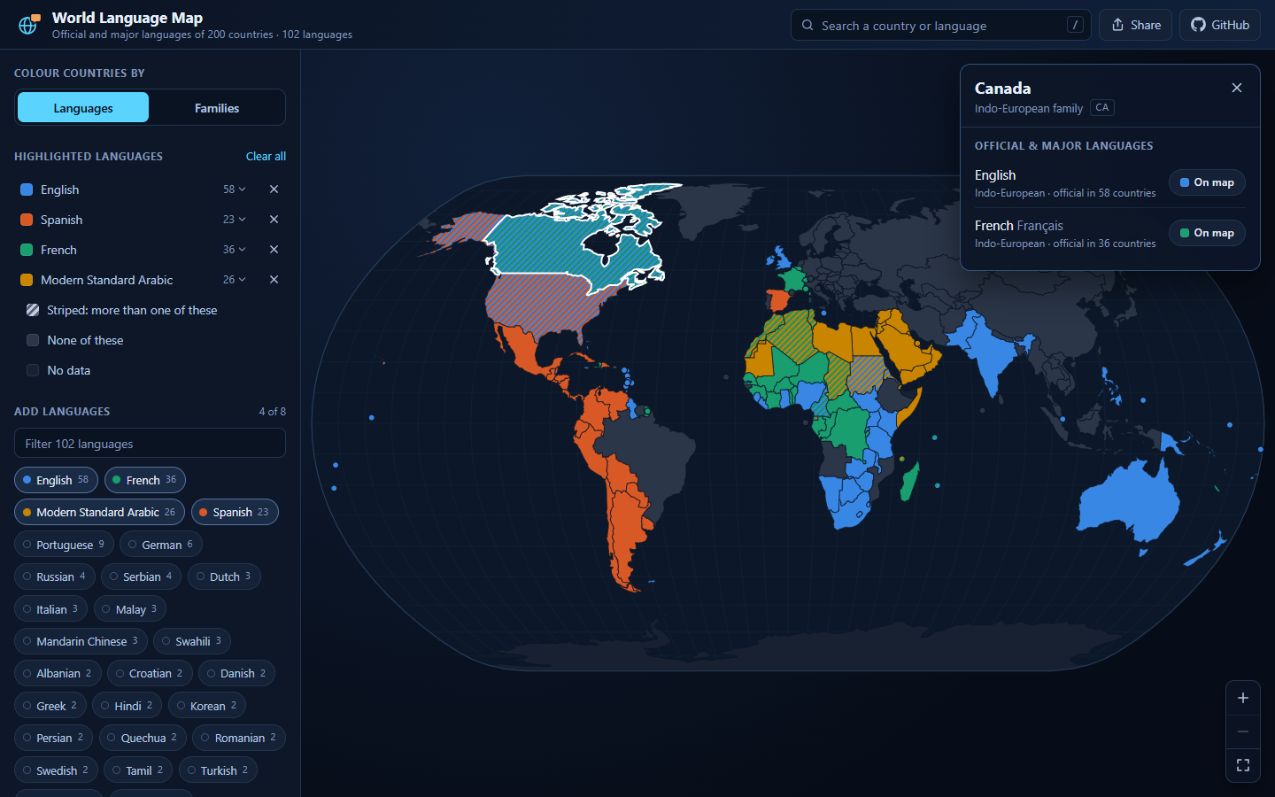
An interactive map of where the world's languages are official. Pick any of 102 languages and every country that lists it lights up in that language's colour; switch to language families and the map is coloured by family instead. Click or tap a country for its languages, and share exactly what you are looking at: the address bar always holds the current view.
→ skulitom.github.io/MapLanguageVisualizer
What you can do
- Highlight languages. Choose as many as you like, from the list or the search box. A language keeps its colour while you add and remove others, and a country that lists more than one of them is striped in all of their colours: Canada in English and French, Chad in French and Arabic, the United States in English and Spanish. A first visit opens with the four most widespread (English, French, Arabic and Spanish) already highlighted.
- See language families. Colour every country by the family of its first-listed language. The seven largest families get their own colour and the seven smallest share a neutral; select any family in the legend to isolate it.
- Look up a country. Click a country for its official and major languages, their native names and families, and how many other countries share each one. Any of them can be added to the map from there.
- Search anything. One box finds countries and languages by English name,
native name or ISO code (
sw,Kiswahili,SG). Press / to jump to it; picking a country flies the map there. - Reach every country. Countries too small for the base map (Singapore, Malta, Bahrain, the Caribbean and Pacific island states) are drawn as dots, and every legend entry opens a list of the countries behind it.
- Share a view. A link such as
#langs=sw,pt&country=MZopens with Swahili and Portuguese highlighted and Mozambique selected. The Share button copies the link, or opens the share sheet on a phone.
On a phone
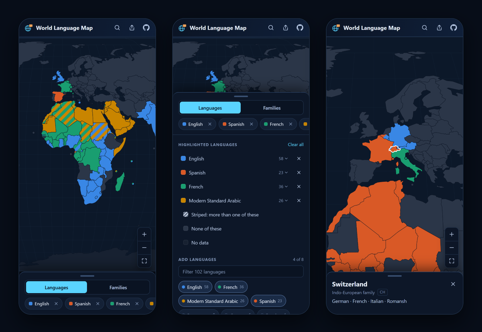
The map takes the whole screen and opens zoomed in far enough to fill it, centred on Europe and Africa. Pinch or use the buttons to zoom, and drag to pan. The controls sit in a sheet along the bottom; tap or swipe its handle to open it. Tapping a country shows its details in the same sheet, and search opens over the header.
Language families
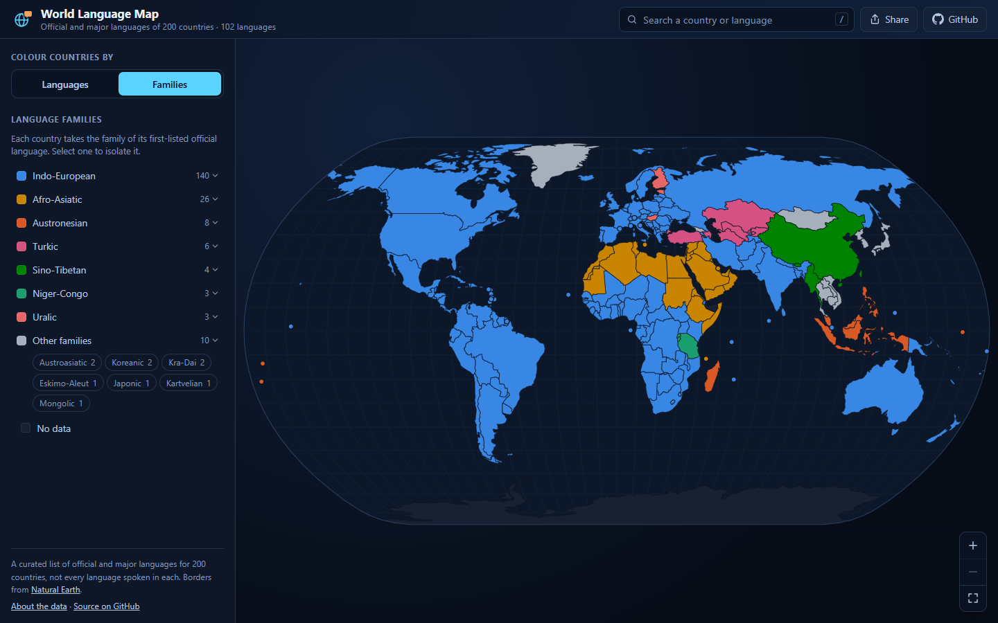
Family mode takes each country's family from its first-listed language. That keeps the map faithful to what the dataset records, but it matters when reading it: wherever English, French, Spanish or Portuguese is listed first, the country counts as Indo-European, which covers most of the Americas and much of Africa. Kenya (English, Swahili) is Indo-European here, while Tanzania (Swahili, English) is Niger-Congo.
Keyboard
| Key | Does |
|---|---|
| / | Jump to the search |
| ↑ ↓ Enter | Pick a search result |
| + − 0 | Zoom in, zoom out, reset (map focused) |
| Arrow keys | Pan (map focused) |
| Esc | Close the country details |
About the data
Languages. A curated list of official and major languages for 200 countries
and territories, 102 languages in all, kept in
scripts/prepare-language-data.ts. Each
country's languages are listed most prominent first. It is not a record of every
language spoken: Nigeria lists English only, and South Africa four of its
official languages (Afrikaans, English, Zulu and Xhosa). Arabic is recorded as
Modern Standard Arabic and Chinese as Mandarin.
Borders. Natural Earth 1:110m admin-0
countries from the world-atlas
package, drawn in the Natural Earth projection. Countries too small to appear at
that scale are drawn as dots at the centre of their largest piece of land in the
1:50m atlas (scripts/prepare-country-points.ts);
Tuvalu and French Guiana, which have no shape of their own even at 1:50m, are
placed by hand. Kosovo is matched by name because the atlas gives it no ISO
code, and Northern Cyprus and Somaliland are shown without language data.
Colours. Selected languages take eight categorical colours in a fixed order, then twenty more chosen to sit as far as possible from those and from each other; a language keeps its colour until it is removed. Only the first eight are checked for colour blindness. The family colours were assigned so that every pair of families sharing a land border stays distinguishable under protanopia and deuteranopia simulation. The legend, tooltips and country lists name everything, so colour is never the only way to tell.
Found a wrong or missing language?
Open an issue, or edit
scripts/prepare-language-data.ts and run npm run data.
Running it locally
Needs Node.js 20.19+ or 22.12+.
npm install
npm run dev
| Script | Does |
|---|---|
npm run dev |
Dev server at http://localhost:5173 |
npm run build |
Type-check and build to dist/ |
npm run preview |
Serve the production build |
npm run lint |
ESLint |
npm run data |
Regenerate src/data/*.json from the scripts in scripts/ |
Every push to master is linted, built and deployed to GitHub Pages by
.github/workflows/deploy-pages.yml.
How it is built
React 19, TypeScript and Vite. The map is one SVG: d3-geo projects the TopoJSON outlines once per size, and d3-zoom handles wheel, drag, pinch and double-tap zoom by transforming a single group, so panning never re-renders the country shapes. There is no backend: the language data ships with the page and the atlas loads as a separate chunk.
src/
  App.tsx               state, URL sync, and the desktop and phone layouts
  components/map/       WorldMap (projection, zoom, dots, stripes), legend, tooltip
  components/controls/  search, mode switch, language picker, country details
  components/layout/    header, bottom sheet, share button
  data/                 the generated JSON and helpers over it
  hooks/, utils/        atlas loading, sizing, colours, search, URL state
scripts/                the language dataset and the dot positions
map_data/               Natural Earth 1:10m shapefiles, kept for reference (not used)
Licence
Code is MIT (see LICENSE). Natural Earth data is in the public
domain, and world-atlas is ISC-licensed.
Questions
What is MapLanguageVisualizer?
skulitom/MapLanguageVisualizer is a public repo on GitHub by skulitom. Interactive world map of where 102 languages are official, across 200 countries. Highlight languages, compare language families, share the view.
Is MapLanguageVisualizer open source?
It declares the MIT license on GitHub.
Does MapLanguageVisualizer run on macOS, Windows or Linux?
Its maker has not tagged a system, so it is unknown here. Its README says what it needs.
How do I install MapLanguageVisualizer?
Open "Take it" on its page: Take My Repo writes an install plan for your machine and hands it to your AI agent (Claude Code, Codex or Cursor), which asks you before each step. Take My Repo has not tested it on any machine.
Is MapLanguageVisualizer still maintained?
Its last change on GitHub was on 2026-09-12. Take My Repo does not judge from that whether it is maintained.